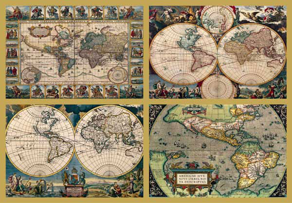
I was curious as to the artists of the maps in Ravensburger
4 Historical World Maps, so I did a bit of digging and came up with the following:
1.
Novus Totuis Terrarum Orbis Geographica by Nicholas Vissccher under another name (Pseudonym)
2.
Orbis Terrarum Nova et Accuratissima also by Nicholas Visscher
3.
Orbis Terrarum Nova et Accuratissima by Johanne A Loon
4.
Americae Sive Novi Orbis Nova by Cosmo and Cartographer Ortelius Abraham (also Oertel and Ortels)
"Orbis Terrarum Nova et Accuratissima", 1659
 |
| Novus Totuis Terrarum Orbis Geographica by Nicholas Visscher |
Includes ornate border panels of engraved figures of Roman emperors, views of Rome, Amsterdam, Jerusalem, Tunis, Mexico, Havana, Pernambuco in Brazil, and San Salvador. Map of the world showing the allegorical figures of the four continents, and north and south polar views. Marco Polo's 'Beach' still shown as part of Magallanica sive Terra Australis Incognita. Relief shown pictorally. Nicolaus Johannes or Joannis Piscator was Visscher's latinised name.
"Novus Totuis Terrarum Orbis Geographica", 1659
Decorative full color example of Nicholas Visscher's highly influential double hemisphere map of the World map, first published in 1658.
As noted by Rodney Shirley:
. . . Visscher's new woldmap in two hemispheres can be regarded as the master forerunner ofa number of highly decorative Dutch world maps produced throughout the remainder of the century. Essentially based upon Blaeu's [wall map of the World] of 1648 . . . the distinct attractiveness of many of the later seventeenth century Dutch world maps can be found in their border decorations . . . [in Visscher's map], artist Nicolaes Berchem has introduced dramatic classical scenes representing the rape of Perephone, Zeus being carried across the heavens in an eagle-drawn chariot, Poseidon commanding his entourage, and Demeter receiving the fruits of the Earth.
Visscher's map also includes a set of smaller polar hemispheric projections at the top and bottom of the map. Visscher's world map would become the proto-type for not only a generation of large format Dutch World maps, it also inspired a series of reduced sized biblical world maps by Stoopendahl and others.
"Orbis Terrarum Nova et Accuratissima Tabula", 1650
 |
| Not the differences between this print and the puzzle version. |
Shows California as an island with the 'Strait of Anian,' also a small portion of New Zealand. Locates Nouv. Albion and Po. S. Franco. Draco." Kashnor dates as 1666, but Shirley identifies this as the second state of this map and gives appeared in information, dating to 1680. Dedication to Charles II. Pitt was supplied this plate by van Waesberge. Artwork around map is taken from Visscher's 1658 map, see 093:057M. Prime meridian: Ferro. Relief: no. Projection: Dual Hemisphere. Printing Process: Copper engraving. References: Shirley 439; Phillips 470; Wagner 388. Verso Text: MS note: 288.
ABRAHAM ORTELIUS
"Americae sive Novi Orbis, Nova Descriptio."
In Theatrum Orbis Terrarum. Antwerp, 1570.
 |
| Interesting differences between this edition and the one in the puzzle. I like the blue ocean... |
ABRAHAM ORTELIUS or Ortel (1527-1598) was a rare book dealer in Antwerp. In 1564 he produced a world map that, influenced by Jacques Cartier's discoveries in 1534-41, showed the St. Lawrence River as a gateway to the Pacific Ocean. Ortelius was generally more of a compiler and publisher of maps and atlases than a cartographer, although he is considered second only to Gerhard Mercator among Flemish cartographers.
Inspired by his friend Mercator and borrowing from him, Ortelius compiled a book of maps coordinated in size and content. This book,
Theatrum Orbis Terrarum, with maps engraved by Franz Hogenberg, is considered the first modern atlas.
The map on display first appeared in Ortelius's atlas. The copy of the atlas in the McGregor Collection is a second edition, printed in the same year as the first edition. The atlas was published in forty-two editions in seven languages from 1570 to 1612. One remarkable feature of this book is that at a time when cartographers copied from the work of others without attribution, Ortelius scrupulously credited ninety-one sources in his atlas.
Americae sive Novi Orbis provides a reasonably accurate outline of North America and improves on the representation of the St. Lawrence River that Ortelius made on his world map. However, the map shows a very narrow Pacific Ocean and situates New Guinea due south of California. Americae sive Novi Orbis also locates Quivira too far to the west. Here Ortelius seems to have relied on Francisco L'pez de G'mara's popular
Historia general de las Indias (1552). In his book, L'pez de G'mara mentions that Coronado had reported that the wealthy kingdom of Quivira was located at 40 degrees latitude. Since Coronado also reported that he had reached the sea, cartographers interpreted this to mean that Quivira must be located near the West coast.
Ortelius's Americae sive Novi Orbis also shows Anian in the Northwest. Anian was a mythical kingdom that Marco Polo mentioned in his travel accounts. Before it appeared in America on this map, Anian was generally believed to be located off the coast of north Asia; curiously, Orteliuss world map published just six years earlier locates Anian on the Asian mainland.
Compared to other contemporary maps, Americae sive Novi Orbis provides more detail because Ortelius was one of the first cartographers outside of Spain to adopt the place-names designated by the Spaniards de Niza, Coronado, and Cabrillo on their American explorations.


